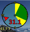
 Holfuy Weather Station on top of Mt. Zion
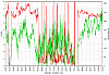 SRRL
BMS
Data Plot: Live - Just south of South Table Mountain in Golden
(green
wind speed in mph on left, red direction in degrees on
right. This tower is a mile or two east of Lookout
Mountain
and Mt.
Zion, so ESE to NE winds are desired there or WNW to N to
ENE
for Green
Mountain)
SRRL
BMS
Data Plot: Live - Just south of South Table Mountain in Golden
(green
wind speed in mph on left, red direction in degrees on
right. This tower is a mile or two east of Lookout
Mountain
and Mt.
Zion, so ESE to NE winds are desired there or WNW to N to
ENE
for Green
Mountain)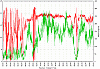 NWTC
M2
Data Plot: Live - Just north of Rocky Flats (same as BMS
but this tower is dedicated to wind research. This tower
is a
mile or two west of the Powerlines
R/C
site NW is desired.. N is flyable, W is
flyable.. Anywhere south of west, or east of north, even a
couple degrees is disasterous)
NWTC
M2
Data Plot: Live - Just north of Rocky Flats (same as BMS
but this tower is dedicated to wind research. This tower
is a
mile or two west of the Powerlines
R/C
site NW is desired.. N is flyable, W is
flyable.. Anywhere south of west, or east of north, even a
couple degrees is disasterous)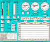 Live
weather display at BMS tower (I think
the wind plots above are more useful)
Live
weather display at BMS tower (I think
the wind plots above are more useful)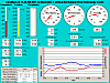 Live
weather display at M2 tower
Live
weather display at M2 tower  Weather
Underground - Wundermap with local personal weather stations
(shows temp and wind barbs)
Weather
Underground - Wundermap with local personal weather stations
(shows temp and wind barbs)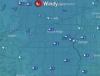 Windy.com - Very powerful interactive map with current and forcast conditions. Several models available.
 Colorado
METARs (shows wind direction and speed for all
known METAR stations in the area)
Colorado
METARs (shows wind direction and speed for all
known METAR stations in the area)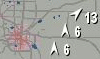 Interesting
animated loop of wind observations over Colorado (click on
little > Play icon)
Interesting
animated loop of wind observations over Colorado (click on
little > Play icon)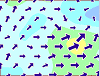 Wind
METAR animation and forecast for SW US region
(switch from Data to Animation, or to Forecast)
Wind
METAR animation and forecast for SW US region
(switch from Data to Animation, or to Forecast)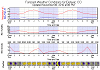 Weather Underground: Computer
Forecast Guidance for KDEN - Forecast graphs (like a graph
of
past conditions but projected out into future)
Weather Underground: Computer
Forecast Guidance for KDEN - Forecast graphs (like a graph
of
past conditions but projected out into future) Weather Underground: Weather
Discussion (technical) (this info is what forecasters
read..
when, why, how, and plenty of probablies)
Weather Underground: Weather
Discussion (technical) (this info is what forecasters
read..
when, why, how, and plenty of probablies)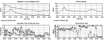 Weather
and wind info at NCAR in south Boulder (want for ESE to
SSE
winds here to catch the big SE
face, can fly E in a pinch)
Weather
and wind info at NCAR in south Boulder (want for ESE to
SSE
winds here to catch the big SE
face, can fly E in a pinch)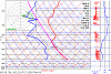 Latest
MAPS/RUC
SkewT sounding diagram plus 7 hours forecast for a
MAPS in an interactive HTML5 app.
Latest
MAPS/RUC
SkewT sounding diagram plus 7 hours forecast for a
MAPS in an interactive HTML5 app.It's set for a grid point closest to Golden Colorado east of Mt. Zion. A tremendous amount of information can be gleaned from these interactive charts.
You can enter your own LAT/LON or a nearby airport code for your own region. Will give you a good idea of potential for thermal convection,
atmospheric stability (inversions and thunderstorms), wind direction at the surface and any otheraltitude, and on and on. Start here to get
soundings for your own area based on LAT-LON. Here are some
tutorials on how to read them. Michigan Tech Skew-T Information, or Down Under Introduction to Skew-Ts
This is the same data that your local and national forecasts are all based on.
Here's a link to a RCGroups thread where I talk about how to use the above Skew-T/Log-P tool with regard to soaring.
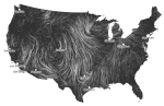 The wind map for
wind/weather junkies, this awesome view shows an animated map of
the entire US based on latest RUC forecast data.
The wind map for
wind/weather junkies, this awesome view shows an animated map of
the entire US based on latest RUC forecast data.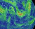 Super cool interactive
animated weather models
for entire earth. It's not just a pretty animation.
You can look at forecast models in the future and past,
all
levels of the atmosphere, including wind, temperature, humidity,
and
much more.
Super cool interactive
animated weather models
for entire earth. It's not just a pretty animation.
You can look at forecast models in the future and past,
all
levels of the atmosphere, including wind, temperature, humidity,
and
much more.  Rocky
Mountain Hanggliding and Paragliding Association weather and
soaring
forecast links
Rocky
Mountain Hanggliding and Paragliding Association weather and
soaring
forecast links